Up to date North Atlantic hurricane and storm activity - hurricane Delta now category 1 having passed over Mexico as category 2
Page down for ongoing storm/hurricane activity.
So far in the 2020 Atlantic hurricane season there has been 25 named storms:
- Tropical Storm Arthur - 16/19 May - not a significant event.
- Tropical Storm Bertha - 27/28 May - the first landfalling TS - not significant at all, caused heavy rainfall in Florida and South Carolina.
- Tropical Depression Cristobal - 1 to 10 June - flooding in Central America, made landfall Louisiana as a tropical depression. Karen Clark catastrophe modelling firm provided an estimate of insured losses of US$150m. This is the earliest a third named storm has ever formed during a hurricane season in the Atlantic Basin. This may or may not indicate increased activity to come.
- Tropical storm Dolly - 23 - 24 June - formed very far North, eventually dispersing.
- Tropical storm Edouard - 6 July - petered out and did not make landfall.
- Tropical storm Fay - 9 July - 11 July - the storm made landfall in New Jersey . Karen Clark catastrophe modelling firm provided an estimate of US$400m insured losses.
- Tropical Storm Gonzalo - 22 July - not a significant event.
- Tropical Storm/Hurricane Hanna - 24/26 July - the eighth named storm and the first hurricane of the 2020 season. The first hurricane since Harvey to make landfall in Texas. Sustained 90mph winds as it came shore at Padre Islands (a long barrier island) on the southern coast of Texas bringing storm surges and heavy rainfall as portrayed in #HurricaneHanna bringing flooding and likely property and marine losses. Not expected to be a significant London market loss. Karen Clark has estimated the insured loss to be US$350m. The catastrophe modeller RMS has opined at US$400m - see here for their article.
- Hurricane Isaias - 29 July - 4 August: No longer an active hurricane having been downgraded after running up E USA and into Quebec. After passing over Andros Island (part of The Bahamas) Isaias made landfall in N Carolinas as a category 1 hurricane bringing heavy rainfall and 85mph force winds. It then interacted with the jet stream and moved quickly as a tropical storm through Virginia, Maryland, Pennsylvania, New York, New England. More information from TSR available here and charts available here. Isaias was the second landfalling hurricane of the 2020 season and the earliest forming "I" named storm in records. KCC has opined (see "Flash Estimate 7/8 available here by providing details) that based upon high resolution models the industry insured loss is estimated at US$4bn for the US and US$200m for Caribbean losses (Dominican Republic and Bahamas). RMS has estimates of US$3-5bn arising from residential property wind-related claims.
- Josephine - 14 - 16 August : dissipated out at sea.
- Kyle: 13/8 - merged with European storm Ellen bringing strong winds to UK 20/8.
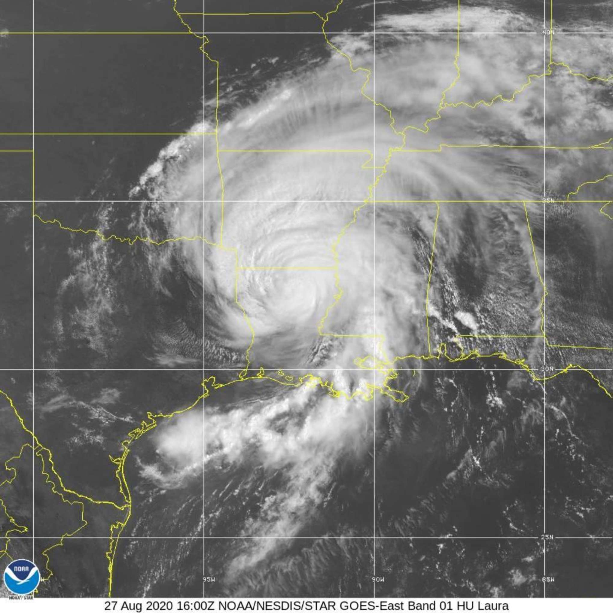
- Laura: 21 to 27 August - category 4 "major" hurricane - having travelled through the Gulf of Mexico strengthened and maximum sustained winds up to 150mph with higher gusts: see here for latest news on industry loss estimates.
- Marco: According to NOAA charts visible here tropical storm Marco downgraded and travelling parallel to the Texas coast with 30 mph winds. No need to monitor this now.
- Nana: 1 Sept - dissipated near Guatemala and Mexico border. See Cyclocane website here
- Omar - 1 Sept - nothing to report - see Cyclocane website here
- Paulette - 7 - 14 Sept - strengthened to a category 1 hurricane with 100mph winds. Passed directly over Bermuda applying hurricane force winds, heavy rainfall, power cuts and storm surge impacts. Hopefully not too extensive damage and less than feared. Paulette is the earliest "P" named storm in recorded history.
- Rene - 7 Sept - was a tropical depression not an issue for the US.
- Sally - 11 - 18 Sept - came ashore bringing storm surge, 100mph winds and excessive rainfall to Louisiana, Mississippi and Alabama and Florida panhandle. Moving at just a few miles mph northwards (weakening rapidly) Sally deviated slightly eastwards at the last moment away from a course towards New Orleans, and made landfall as a category 2 hurricane between the Alabama coastal cities of Mobile and Pensacola bringing approx a 6' storm surge causing flooding, and because Sally moved so slowly, between 25 to 35 inches of rainfall, causing flash flooding. Residential properties at Gulf Shores have been severely damaged, read Bob Henson blog here for up to date comment. More than 500,000 homes and businesses lost power in Alabama and the Florida Panhandle. Sally is the fourth US landfalling hurricane of the season. Hurricane Ivan (2004) which was a much broader storm than Sally and was a strong category 3 hurricane caused about US$8bn of insured losses. Recently Karen Clark & Co has provided an estimate of insured losses of US$2bn: wind damage will be covered by insurers but surge and inland flood damage will fall to the NFIP, if taken up at all. AIR Worldwide has posted "AIR estimates that industry insured losses to onshore property resulting from Hurricane Sally’s winds, storm surge, and inland flood will range from USD 1 billion to USD 3 billion, with wind representing the majority of the losses."
- Teddy - 14 Sept and ongoing - off Novia Scotia - see Tiger Risk tracking here. Teddy brushed past east of Bermuda bringing strong winds, heavy rainfall and storm surge.
- Vicky - 14 Sept - 40mph winds tropical storm - not likely to be an issue.
- Wilfred - 20 September - a non-event.
- Alpha - 18 Sept - formed so far north and east that it ended up in Portugal!
- Beta - 20 - 23 Sept - tropical storm bring heavy rain and flash floods to parts of Mexico and Gulf coast.
- Gamma - 3/10 - just remnants now over Central America - see
- Delta - 5/10 ongoing - now a category 1 hurricane with 90mph winds having crossed over northern tip of Yucatan peninsula, Mexico as a category 2. Delta reached category 4 for an hour or two prior to that but wind shear robbed it of much of its intensity. Click here to see Delta's suggested path according to Tiger Risk (click on "Delta" once on the screen) which suggests the possible path through the Gulf of Mexico and making landfall by the weekend in Louisiana. Delta is the 25th named storm of this year. The worldwide (re)insurance broker BMS has written an interesting article available on their website here. Satellite image of Delta available here Forecast track available here from National Hurricane Center
Aon the global (re)insurance broker has commented recently "Despite the high number of landfalls, this has not resulted in a record level of catastrophe loss. The landfalls – including hurricanes Laura, Hanna, Isaias, and Sally – largely occurred in areas with lower population density than seen in recent high-loss years in 2018, 2017, 2012, and 2008."
Future storms
After Wilfred the names of storms switched to the Greek alphabet: Delta, Epsilon, etc.,. This is only the second time the Greek alphabet has been used to name storms. The first was during the 2005 hurricane season, where the last named storm was Zeta.
Hurricanes have winds of winds of at least 74 mph; major hurricanes at least 111 mph. See Saffir-Simpson categories here.
Affect of Covid-19 on insured losses
Karen Clark has written a short article available here as a pdf which examines the issue that losses from hurricanes will increase as a result of the complications caused by Covid by betweeen 20 to 25%.
----------------------------------------------------
Mid-August updated hurricane forecasts
"Skill starts to climb as the hurricane season approaches with moderate-to-good skill levels being achieved, on average, by early August." says TSR and so relevant to see the recently produced forecasts, tabled below:
| Mid-August forecasts for storm and hurricane activity | ||||||||||
| 1950 - 2019 average | 2010 - 2019 average | UK Met (May) | CSU (May) | CSU (Aug) | NOAA (May) | NOAA (Aug) | TSR /UCL (May) | TSR / UCL (Aug) | ||
| Tropical Storms | 12 | 16 | 13 | 19 | 24 | 13 - 19 | 19 - 25 | 17 | 24 | |
| Hurricanes | 6 | 7 | 7 | 9 | 12 | 6 - 10 | 7 - 11 | 8 | 10 | |
| Major hurricanes | 3 | 3 | 3 | 4 | 5 | 3 - 6 | 3 - 6 | 3 | 4 | |
| TSR / UCL = | University College London for Tropical Storm Risk | |||||||||
| CSU = | Colorado State University | |||||||||
| NOAA = | National Oceanic and Atmospheric Administration | |||||||||
The Jeff Masters and Bob Henson Blog contains much useful information on the formation and possible track of hurricanes - Jeff's last year of providing his commentary here - he has moved to Yale Climate Connections and his informed commentary on all matters meteorological are available here called "Eye On The Storm."
Signup here for alerts from Tiger Risk
Signup here for alerts from Tropical Storm Risk (TSR)
------------------------------------------------
If you would like to be added to the distribution list of published articles, please email: [email protected]